

Whittier road closure plan
A Public Ready road closure example showing a Phase I closure footprint, advance warning signs, matchlines, temporary parking notes, and a detour map in Whittier.
DRAFTED BY PUBLIC READY
What this example shows.
- Road closure footprint and advance warning signs
- Matchlines across a large work-area drawing
- Detour map and temporary parking notes
One supplied sheet from a six-sheet plan set; the original sheet numbering is retained.
Phase I road closure and detour layout - original sheet 2 of 6
Open full-size image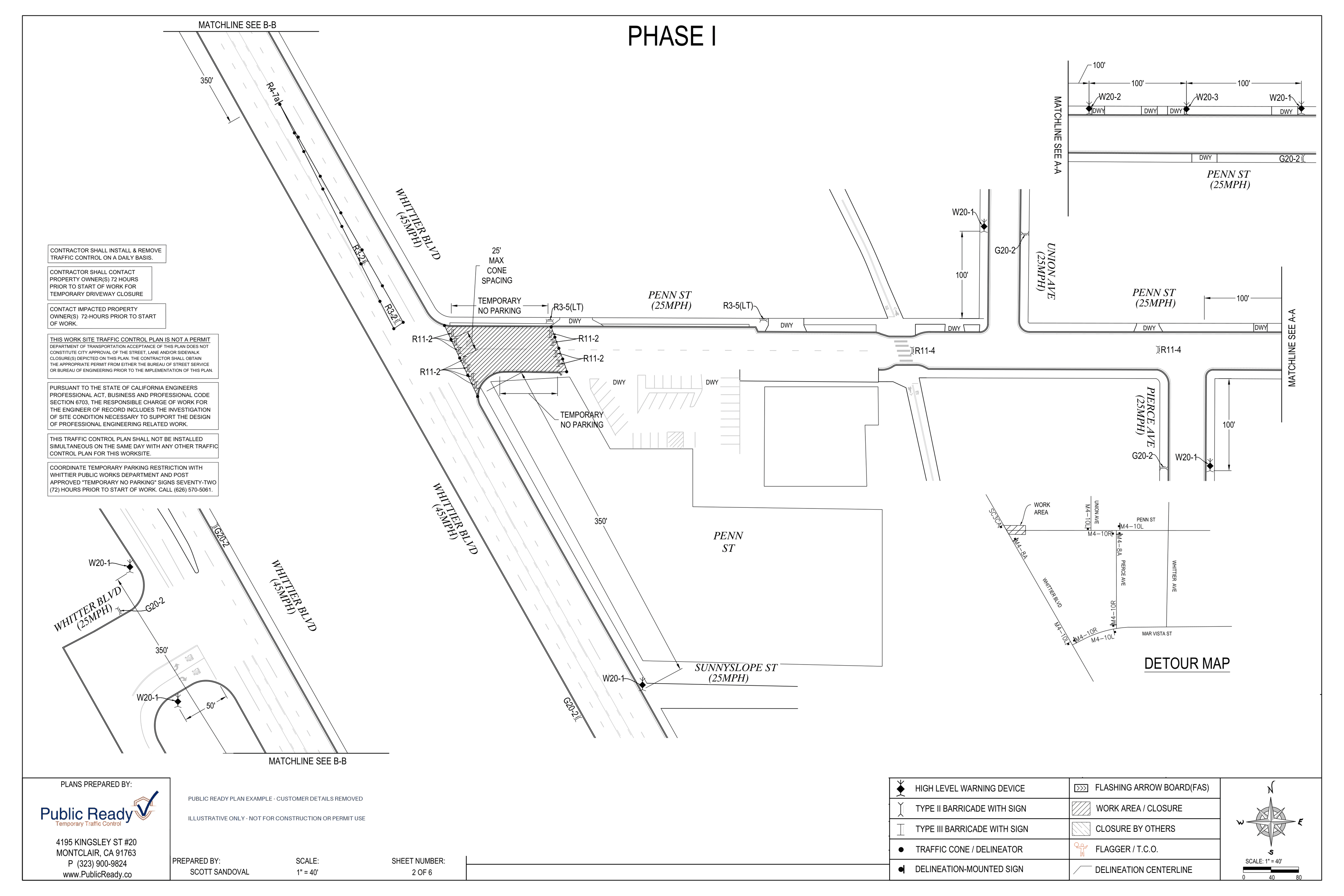
Read sheet 1 description
Sheet overview
The supplied drawing is original sheet 2 of 6, titled Phase I. It shows a full-width hatched closure at the western end of Penn Street where Penn meets Whittier Boulevard. Penn Street continues across the page past Union Avenue and Pierce Avenue, with warning layouts continued through matchlines A-A and B-B.
Layout and relationships
The hatched work area blocks the Penn Street approach at Whittier Boulevard. R11-2 road-closed signs and barricades mark its ends; R11-4 signs are shown farther along Penn Street. Temporary No Parking limits are marked on both sides beside the work. Cones are labeled 25 feet maximum spacing. R3-5(LT) turn signs appear at nearby driveways, and R3-2 signs are shown along the Whittier Boulevard approach.
The upper-right continuation of Penn Street shows W20-2, W20-3, and W20-1 signs at successive 100-foot intervals, with G20-2 on the other side. Union Avenue and Pierce Avenue have W20-1 warning and G20-2 end-work signs, with 100-foot dimensions shown. Whittier Boulevard approaches show 350-foot dimensions, with another 50-foot callout in the lower-left continuation. Sunnyslope Street is labeled beside a W20-1 warning sign on Whittier Boulevard.
The lower-right detour map places the work at Penn Street and Whittier Boulevard. The alternate street network follows Penn Street east to Pierce Avenue, Pierce south to Mar Vista Street, and Mar Vista west to Whittier Boulevard. Union Avenue is shown between Whittier and Pierce, and a separate Whittier Avenue label appears in the inset. M4-8A and M4-10 directional detour-sign callouts identify the turns and the end of the route.
Whittier Boulevard is labeled 45 mph. Penn Street, Union Avenue, Pierce Avenue, Sunnyslope Street, and the smaller lower-left Whittier Boulevard branch are labeled 25 mph. The sheet has a north arrow, a graphic scale, and a title-block scale of 1 inch equals 40 feet. Its device legend identifies warning devices, Type II and III barricades with signs, cones or delineators, delineation-mounted signs, a flashing arrow board, work and other-closure hatching, a flagger or traffic control officer, and a delineation centerline.
Notes on the historical example
These notes describe the redacted drawing. They apply to the original example and may not reflect current agency requirements. They are not instructions for a new project.
- Historical notes call for daily installation and removal of traffic control, 72-hour notice to property owners for temporary driveway closure, and 72-hour notice to impacted property owners before work.
- The sheet states that the work-site traffic control plan is not a permit and that transportation acceptance does not itself authorize the depicted closure. The original note names the Bureau of Street Service or Bureau of Engineering for appropriate permitting before implementation.
- A historical engineering note references California Business and Professions Code section 6703 and site-condition investigation by the engineer of record. This reports the original drawing, not current legal requirements.
- The drawing says not to install this plan simultaneously with another traffic control plan for the worksite on the same day.
- A historical parking note calls for coordination with Whittier Public Works, posting approved Temporary No Parking signs 72 hours before work, and calling the number printed on the drawing, (626) 570-5061. That historical contact has not been verified as current.
- Only one sheet of the original six-sheet set is supplied. The redacted copy is illustrative only, not for construction or permit use.
LET’S GET YOUR PROJECT READY