

Where is the work?
Share the actual project address, affected street, nearest cross streets, and whether work affects a travel lane, sidewalk, bicycle facility, or curb space.
PUBLIC READY / PLANNING RESOURCES
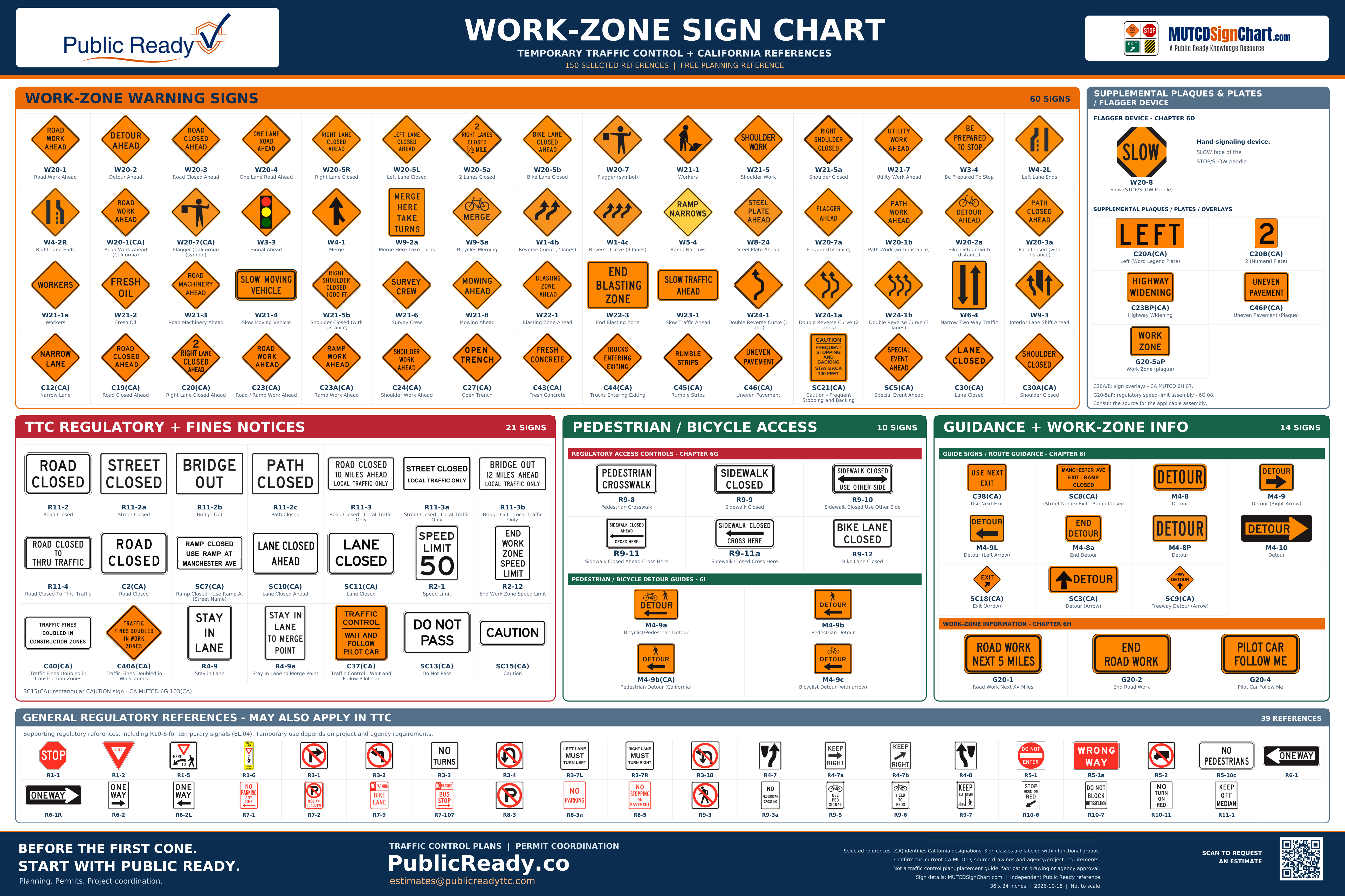
Recognize common signs. Ask better project questions. This chart connects 150 selected sign references with the information needed to begin planning and agency coordination.
USE THE CHART AS A STARTING POINT
A sign chart helps identify a design. It does not specify the sign spacing, taper, device arrangement, accessible route, or work phases for your project. Those decisions depend on the actual conditions, current standards, and reviewing agency requirements.
Public Ready provides traffic control planning, permit and agency coordination, Temporary No Parking support, and project-readiness documentation. General field traffic-control labor, flagging, and device deployment are performed by separate execution providers. Professional engineering review or stamping can be coordinated when required.
BEFORE YOU CHOOSE A SIGN PACKAGE
Share the actual project address, affected street, nearest cross streets, and whether work affects a travel lane, sidewalk, bicycle facility, or curb space.
Identify pedestrian routes, accessible paths, driveways, transit stops, businesses, and emergency access that may be affected. A sidewalk-closure sign alone does not establish an accessible alternate route.
Provide work dates, hours, equipment placement, delivery or lifting activity, and any phases that change access or traffic patterns.
Confirm the roadway authority, permit conditions, required documents, and whether professional engineering review or stamping must be coordinated.
Open each sign on MUTCDSignChart.com for its meaning, available dimensions, California notes, and official references. Legends and directional variants may differ from the example shown here.
W20-1
Warns approaching drivers that a work operation is taking place on or near the roadway ahead so they can slow down and stay alert for changing conditions.
Read the sign reference →W20-2
Warns drivers that a detour is ahead and that the normal route will be interrupted, prompting them to prepare to follow an alternate path.
Read the sign reference →W20-3
Warns that the road ahead is closed and that through travel will not be possible, giving drivers time to turn or follow a detour before reaching the closure.
Read the sign reference →W20-4
Warns that two-way traffic will be reduced to a single shared lane ahead, where opposing directions must take turns through the work area.
Read the sign reference →W20-5R
Warns that the right-hand travel lane is closed ahead and that traffic in that lane must merge left before the work area. The distance legend may read AHEAD, a distance in feet, or a distance in miles.
Read the sign reference →W20-5L
Warns that the left-hand travel lane is closed ahead and that traffic in that lane must merge right before the work area. The distance legend may read AHEAD, a distance in feet, or a distance in miles.
Read the sign reference →W20-5a
Warns that two travel lanes are closed ahead (shown with the distance to the closure) so drivers can merge out of the affected lanes well in advance.
Read the sign reference →W20-5b
Warns that the bicycle lane is closed ahead, with the word legend BIKE LANE CLOSED (a distance line is added on the advance version), so bicyclists can prepare to merge or follow a signed alternate route before reaching the work.
Read the sign reference →W20-7
Uses a flagger symbol to warn drivers that a flagger is controlling traffic ahead and that they must be prepared to stop or follow the flagger's directions.
Read the sign reference →W21-1
Uses a worker symbol to warn that workers are present on or near the roadway ahead, signaling drivers to reduce speed and increase caution.
Read the sign reference →W21-5
Warns that work is taking place on the shoulder ahead, alerting drivers to workers and equipment near the edge of the traveled way.
Read the sign reference →W21-5a
Warns that the shoulder is closed ahead and is not available for stopping, disabled vehicles, or travel through the work area.
Read the sign reference →W21-7
Warns that utility work is taking place on or near the roadway ahead, alerting drivers to utility crews, equipment, and possible lane or shoulder impacts.
Read the sign reference →W3-4
Warns drivers that they may have to stop ahead, giving advance notice of a flagging station, queue, or signal that can require stopping.
Read the sign reference →W4-2L
Warns that the left travel lane ends ahead and that traffic in the left lane must merge into the adjacent lane where the roadway narrows.
Read the sign reference →W4-2R
Warns that the right travel lane ends ahead and that traffic in the right lane must merge into the adjacent lane where the roadway narrows.
Read the sign reference →W20-1(CA)
Warns of road work ahead in a California temporary traffic-control arrangement. This catalog entry uses a California label for the federal W20-1 design; the linked official drawing is W20-1.
Read the sign reference →W20-7(CA)
Uses the flagger symbol to warn of a flagging operation ahead. This catalog entry uses a California label for the federal W20-7 design; the linked official drawing is W20-7.
Read the sign reference →W3-3
Warns with the traffic-signal symbol that a traffic control signal is ahead, giving drivers advance notice to be prepared to stop at the signal.
Read the sign reference →W4-1
Warns that another stream of traffic merges into the roadway ahead. The symbol shows the side from which the merging traffic enters.
Read the sign reference →W9-2a
Supports a zipper (late) merge by telling drivers to merge at the closure point and take turns, keeping both lanes in use until the merge point.
Read the sign reference →W9-5a
Warns drivers that bicyclists may merge into or share the travel lane ahead, prompting added caution where a bike facility is interrupted.
Read the sign reference →W1-4b
Warns of a two-lane reverse-curve alignment ahead — a curve in one direction followed by a curve in the other — such as a lane shift around a work area.
Read the sign reference →W1-4c
Warns of a three-lane reverse-curve alignment ahead — a curve in one direction followed by a curve in the other — such as a multilane lane shift around a work area.
Read the sign reference →W5-4
Warns that the width of a ramp is reduced ahead, so drivers approach the narrowed section with caution.
Read the sign reference →W8-24
Warns that steel plates (trench plates) are in place on the roadway ahead, alerting drivers to the change in surface and possible bump.
Read the sign reference →W20-7a
Warns that a flagger is controlling traffic ahead. The distance line identifies how far ahead the flagging operation is, or uses AHEAD in place of a numerical distance.
Read the sign reference →W20-1b
Warns path users that work is taking place ahead on the path. The distance legend gives advance notice before users reach the work area.
Read the sign reference →W20-2a
Warns bicyclists that a detour is ahead. Its bicycle symbol, DETOUR legend, and distance line identify an upcoming change from the normal bicycle route.
Read the sign reference →W20-3a
Warns that a path is closed ahead. The distance line gives users advance notice so they can reach an available alternate route before the closure.
Read the sign reference →W21-1a
Uses the word WORKERS to warn that workers are present on or near the roadway. This is the word-message counterpart to the W21-1 worker-symbol sign.
Read the sign reference →W21-2
Warns of freshly applied oil or road-treatment material on the surface ahead. Drivers should expect a surface condition associated with the maintenance operation.
Read the sign reference →W21-3
Warns that road machinery is operating ahead. It alerts drivers to equipment working on, entering, or moving near the traveled way.
Read the sign reference →W21-4
Warns approaching traffic of a slow-moving work vehicle. It is a rectangular work-zone message sign, distinct from the triangular slow-moving-vehicle emblem.
Read the sign reference →W21-5b
Warns that the indicated left or right shoulder is closed ahead. The distance line gives AHEAD or a numerical distance; the linked sheet contains both directional variants.
Read the sign reference →W21-6
Warns that a survey crew is working near the roadway. Drivers should watch for people and surveying equipment in the work area.
Read the sign reference →W21-8
Warns that roadside mowing is taking place ahead. Drivers should watch for mowing equipment and associated maintenance vehicles near the roadway.
Read the sign reference →W22-1
Warns that a blasting zone is ahead. It introduces the area where additional blasting-operation instructions may apply.
Read the sign reference →W22-3
Marks the end of a signed blasting zone. It closes out the zone identified by the blasting warning and associated instruction signs.
Read the sign reference →W23-1
Warns approaching drivers that traffic ahead is moving slowly. It gives advance notice of a queue or work operation that can require a substantial speed reduction.
Read the sign reference →W24-1
Shows one traffic lane following a double reverse curve through a temporary alignment. The left and right variants depict the direction of the first change in alignment.
Read the sign reference →W24-1a
Shows two traffic lanes following a double reverse curve through a temporary alignment. Its two arrows depict the lanes continuing together through the alignment change.
Read the sign reference →W24-1b
Shows three traffic lanes following a double reverse curve through a temporary alignment. Its three arrows depict the lanes continuing together through the alignment change.
Read the sign reference →W6-4
The W6-4 Narrow Two-Way Traffic sign warns that the roadway ahead narrows to a two-way, two-lane operation with opposing traffic on the other side of the center line. The two opposing arrows indicate traffic moving in both directions past the sign. In temporary traffic control it is shown on an orange background, commonly where a lane closure or crossover sets up a narrow two-way section.
Read the sign reference →W9-3
Warns of an interior lane shift ahead in a temporary traffic arrangement. The arrows show the changed paths through the lane configuration.
Read the sign reference →C12(CA)
Warns that a traffic lane is narrow. Drivers should expect reduced lateral clearance in the signed area.
Read the sign reference →C19(CA)
Warns of a road closure ahead. It gives drivers advance notice before they reach the closure.
Read the sign reference →C20(CA)
Warns that the right lane is closed ahead. It gives drivers advance notice to prepare for the lane closure.
Read the sign reference →C23(CA)
Warns of work ahead on a road or ramp. The older drawing permits ROAD WORK AHEAD and RAMP WORK AHEAD; the current California manual identifies the ramp application as C23(CA).
Read the sign reference →C23A(CA)
Warns that ramp work is taking place ahead. It alerts drivers to work affecting the ramp.
Read the sign reference →C24(CA)
Warns that shoulder work is taking place ahead. Drivers should expect workers or equipment near the edge of the traveled way.
Read the sign reference →C27(CA)
Warns of an open trench in the work area. The message identifies an excavation hazard.
Read the sign reference →C43(CA)
Warns of fresh concrete in the work area. It identifies the recently placed material that traffic must avoid disturbing.
Read the sign reference →C44(CA)
Warns that trucks are entering or exiting the roadway. Drivers should watch for construction-vehicle movements at the access point.
Read the sign reference →C45(CA)
Warns of rumble strips ahead or in the signed work area. It alerts drivers to the surface treatment and its vibration or sound.
Read the sign reference →C46(CA)
Warns of uneven pavement. It calls attention to a change in roadway surface level in the work area.
Read the sign reference →SC21(CA)
Warns that the work vehicle stops and backs frequently, and tells following traffic to stay back 100 feet. It identifies the vehicle's operating pattern and the displayed following-distance instruction.
Read the sign reference →SC5(CA)
Warns that a special event is ahead. Drivers should expect event-related traffic or temporary traffic controls.
Read the sign reference →C30(CA)
Identifies a closed lane. It marks the lane restriction in the work area.
Read the sign reference →C30A(CA)
Identifies a closed shoulder. It marks the area that is unavailable for shoulder use.
Read the sign reference →W20-8
The SLOW face of a flagger's STOP/SLOW paddle tells approaching traffic to proceed slowly when directed by the flagger. The linked drawing also shows the separate R1-1 STOP face on the reverse side.
Read the sign reference →C20A(CA)
Provides a LEFT overlay for a compatible lane-closure warning sign. It changes the indicated side of the closure and is not a standalone message.
Read the sign reference →C20B(CA)
Provides a numeral overlay for a compatible lane-closure warning sign. The installed numeral specifies the number of affected lanes.
Read the sign reference →C23BP(CA)
Identifies highway-widening work. The supplemental message describes the type of construction operation.
Read the sign reference →C46P(CA)
Adds an UNEVEN PAVEMENT message to an associated warning-sign assembly. The plaque identifies the surface condition addressed by the warning.
Read the sign reference →G20-5aP
Adds the WORK ZONE designation to an associated sign assembly. As a plaque, it supplements the main message rather than providing a complete standalone instruction.
Read the sign reference →R11-2
A regulatory sign stating that the road is closed to all traffic, posted at the closure point typically on a barricade across the roadway.
Read the sign reference →R11-2a
Indicates that a street is closed to traffic, used to legally close a local street for work or an event.
Read the sign reference →R11-2b
Identifies a bridge that is out of service or impassable. Road users cannot continue across the closed bridge and need an alternate route.
Read the sign reference →R11-2c
Indicates that a shared-use path (pedestrian/bicycle) is closed, directing users away from the closed path.
Read the sign reference →R11-3
Announces a road closure at the displayed distance while allowing local traffic access before the closure. Through traffic needs an alternate route.
Read the sign reference →R11-3a
A regulatory sign stating that the street is closed except to local traffic, with the word legend STREET CLOSED / LOCAL TRAFFIC ONLY (a distance line is added on the advance version). Through traffic must use a detour; residents, businesses, and deliveries within the closure may proceed.
Read the sign reference →R11-3b
Warns that a bridge ahead is out (impassable) and that only local traffic should proceed toward it, with through traffic using an alternate route.
Read the sign reference →R11-4
A regulatory sign stating that through travel is closed while still allowing local access to properties within the closure.
Read the sign reference →C2(CA)
Identifies a road closure at the signed location. Through travel beyond the closure is not available.
Read the sign reference →SC7(CA)
Announces a ramp closure and identifies the street where drivers should use an alternate ramp. The street name is specific to the closure plan.
Read the sign reference →SC10(CA)
Provides advance notice that a lane is closed. The message alerts approaching traffic to the lane restriction.
Read the sign reference →SC11(CA)
Identifies a closed lane in the signed traffic-control arrangement.
Read the sign reference →R2-1
Posts the maximum legal speed for the roadway, establishing the enforceable speed limit drivers must not exceed.
Read the sign reference →R2-12
Marks the end of a work-zone speed limit. Drivers must continue to follow the applicable speed limit and other posted controls beyond that point.
Read the sign reference →C40(CA)
Displays the message that traffic fines are doubled in construction zones. The sign communicates the penalty notice; the applicable law determines the offenses and conditions covered.
Read the sign reference →C40A(CA)
Displays the message that traffic fines are doubled in work zones. The sign communicates the penalty notice without defining the legal conditions for a particular violation.
Read the sign reference →R4-9
Instructs drivers to remain in their lane through the signed area. It discourages lane changing where maintaining lane position is required.
Read the sign reference →R4-9a
Instructs drivers to remain in their lane until they reach the merge point. It identifies an arrangement in which the merge occurs at the designated point rather than earlier in the approach.
Read the sign reference →C37(CA)
Tells traffic to wait and then follow the pilot car. It explains the controlled movement through the work area.
Read the sign reference →SC13(CA)
Directs drivers not to pass in the signed area. It identifies the passing restriction in the traffic-control arrangement.
Read the sign reference →SC15(CA)
Displays a general CAUTION message for the signed traffic-control condition. The message does not identify a specific hazard by itself.
Read the sign reference →R9-8
Identifies a designated pedestrian crosswalk with the word legend PEDESTRIAN CROSSWALK, directing pedestrians to cross at that location.
Read the sign reference →R9-9
Informs pedestrians that the sidewalk is closed at that location, signaling that they must not continue along the blocked walkway.
Read the sign reference →R9-10
Tells pedestrians that the sidewalk is closed and directs them to use the sidewalk on the opposite side of the street.
Read the sign reference →R9-11
Advises pedestrians of a sidewalk closure ahead and directs them to cross at the indicated location before reaching the closure.
Read the sign reference →R9-11a
Marks the point where pedestrians should cross because the sidewalk is closed, directing them to the open side at the crossing.
Read the sign reference →R9-12
Identifies a bicycle lane that is closed. It marks the restriction itself, rather than serving as advance warning of a closure farther ahead.
Read the sign reference →M4-9a
Directs both bicyclists and pedestrians along a detour route with the bicycle and pedestrian symbols, the word DETOUR, and a directional arrow (M4-9aL/M4-9aR directional versions).
Read the sign reference →M4-9b
Directs pedestrians along an alternate accessible route when a sidewalk or crosswalk on their normal path is closed.
Read the sign reference →M4-9b(CA)
Directs pedestrians along a detour using the pedestrian symbol and an arrow. This catalog entry uses a California label for the federal M4-9b design; the linked official drawing is M4-9b.
Read the sign reference →M4-9c
Directs bicyclists along a detour in the direction of the arrow. The bicycle symbol identifies the road users to whom the detour applies.
Read the sign reference →C38(CA)
Directs drivers to use the next exit. It identifies the alternate departure in a temporary traffic-control arrangement.
Read the sign reference →SC8(CA)
Identifies the named exit as having a closed ramp. The street name tells drivers which departure is affected.
Read the sign reference →M4-8
Identifies an approved detour route, marking the path drivers should follow around a closure when used with directional arrows.
Read the sign reference →M4-9
Combines the word DETOUR with a directional arrow to point drivers toward the correct turn along the detour route. The official FHWA designation is M4-9 “Detour”; this site labels the right- and left-arrow orientations as M4-9 (Right Arrow) and M4-9L (Left Arrow) only to distinguish the two directions.
Read the sign reference →M4-9L
Combines the word DETOUR with a left-pointing arrow to direct drivers to turn left at this point of the detour route. Note: “M4-9L” is a directional label used on this site to identify the left-arrow version of the detour marker. FHWA does not issue M4-9L as a separate sign code — the official designation is M4-9 “Detour,” which is shown with either a left- or right-pointing arrow as the route requires.
Read the sign reference →M4-8a
Marks the end of a signed detour route. It tells road users that the detour guidance has concluded at that point.
Read the sign reference →M4-8P
Identifies an associated route-sign assembly as a detour. The plaque works with the route number and directional information in the assembly.
Read the sign reference →M4-10
Directs traffic along a detour using the word DETOUR within a large horizontal arrow. The linked sheet provides left- and right-pointing variants.
Read the sign reference →SC18(CA)
Identifies an exit direction in a temporary traffic-control arrangement. The arrow guides drivers to the available exit path.
Read the sign reference →SC3(CA)
Directs traffic along a detour with a horizontal arrow. The arrow identifies the route to follow around the closure.
Read the sign reference →SC9(CA)
Directs traffic along a freeway detour using an arrow. The optional freeway identification distinguishes the detour route being followed.
Read the sign reference →G20-1
Informs drivers of the total length of a work zone, telling them how many miles of road work to expect ahead.
Read the sign reference →G20-2
Marks the downstream end of a road-work zone. It identifies the end of the work signing and does not itself change a posted speed limit.
Read the sign reference →G20-4
Tells traffic to follow the pilot car through the controlled section. The sign identifies the vehicle leading traffic through the work area.
Read the sign reference →R1-1
Requires every driver to come to a complete stop at the marked stop line, crosswalk, or intersection before proceeding when it is safe.
Read the sign reference →R1-2
Requires drivers to slow down and yield the right-of-way to traffic and pedestrians, stopping only if necessary to avoid a conflict.
Read the sign reference →R1-5
Identifies the point where drivers are to yield for pedestrians at a crossing. The arrow points toward the intended yielding location in advance of the crosswalk.
Read the sign reference →R1-6
An in-street crossing sign reminding drivers of the requirement to yield to pedestrians within the crosswalk. Its pedestrian and yield symbols reinforce the crossing rule at the location.
Read the sign reference →R3-1
Prohibits a right turn at the intersection or location where the sign is posted, making it a traffic law violation to turn right.
Read the sign reference →R3-2
Prohibits a left turn at the intersection or location where the sign is posted, making it a traffic law violation to turn left.
Read the sign reference →R3-3
Prohibits all turning movements — both right and left turns — at the intersection where the word-legend NO TURNS sign is posted.
Read the sign reference →R3-4
Prohibits a U-turn at the location where the sign is posted, shown with the U-turn arrow symbol inside a red prohibition circle and slash.
Read the sign reference →R3-7L
Requires all traffic in the left lane to turn left at the intersection. It is a word-message lane-use control sign that removes any doubt about the mandatory movement for that lane.
Read the sign reference →R3-7R
Requires all traffic in the right lane to turn right at the intersection. It is a word-message lane-use control sign that removes any doubt about the mandatory movement for that lane.
Read the sign reference →R3-18
Prohibits both a left turn and a U-turn at the location where the sign is posted, shown with the combined left-turn and U-turn arrow symbol inside a red prohibition circle and slash.
Read the sign reference →R4-7
Directs traffic to pass to the right of an obstruction or traffic island. The curved arrow shows the required side of passage.
Read the sign reference →R4-7a
Directs traffic to pass to the right of an obstruction. This version combines the words KEEP RIGHT with a horizontal right-pointing arrow.
Read the sign reference →R4-7b
Directs traffic to pass to the right of an obstruction. This version combines the words KEEP RIGHT with an upward diagonal right-pointing arrow.
Read the sign reference →R4-8
Directs traffic to pass to the left of an obstruction or traffic island. The curved arrow shows the required side of passage.
Read the sign reference →R5-1
Prohibits entry into a roadway or lane, telling drivers they must not proceed past the sign in that direction.
Read the sign reference →R5-1a
Warns drivers that they are traveling against the permitted direction of traffic. The red WRONG WAY sign faces traffic entering or proceeding in the prohibited direction.
Read the sign reference →R5-2
Prohibits trucks from entering the roadway or route where the sign is posted, shown with the truck symbol inside a red prohibition circle and slash.
Read the sign reference →R5-10c
Prohibits pedestrians from entering the signed roadway or facility. Its word message identifies the road-user group to which the restriction applies.
Read the sign reference →R6-1
Indicates that traffic on the roadway flows in one direction only, to the left, as shown by the horizontal arrow.
Read the sign reference →R6-1R
Indicates that traffic on the roadway flows in one direction only, to the right, as shown by the horizontal arrow.
Read the sign reference →R6-2
Indicates that traffic on the roadway flows in one direction only, to the right, as shown by the arrow below the ONE WAY legend.
Read the sign reference →R6-2L
Indicates that traffic on the roadway flows in one direction only, to the left, as shown by the arrow below the ONE WAY legend.
Read the sign reference →R7-1
Prohibits parking at any time within the signed area. Any directional arrows on the installed sign define the extent of the restriction.
Read the sign reference →R7-2
Prohibits parking during the days and hours displayed on the sign. The schedule on the installed sign determines when the restriction applies.
Read the sign reference →R7-9
Prohibits parking in the bicycle lane. The bicycle-lane message identifies the space that must be kept clear of parked vehicles.
Read the sign reference →R7-107
Prohibits parking in the signed bus-stop area. It identifies curb space that must remain available for bus service.
Read the sign reference →R8-3
Uses the crossed-out P symbol to prohibit parking. Supplemental information or arrows, where provided, define the location or extent of the restriction.
Read the sign reference →R8-3a
Uses the words NO PARKING to prohibit parking in the signed area. It is the word-message alternative to the parking-prohibition symbol.
Read the sign reference →R8-5
Prohibits stopping on the paved roadway. Its restriction addresses stopping, rather than only leaving a vehicle parked.
Read the sign reference →R9-3
The R9-3 No Pedestrians sign prohibits pedestrian travel along or across the roadway at that location. It uses the pedestrian symbol within a red circle and diagonal slash, and is typically posted where a sidewalk or crossing is closed and pedestrians must use an alternate route.
Read the sign reference →R9-3a
Prohibits pedestrians from crossing at the location where the word-legend NO PEDESTRIAN CROSSING sign is posted, directing them to a designated crossing instead.
Read the sign reference →R9-5
Directs bicyclists to use the pedestrian signal indications at the crossing. The message identifies which signal controls the bicycle crossing movement.
Read the sign reference →R9-6
Requires bicyclists to yield the right-of-way to pedestrians, shown with the bicycle symbol and the legend YIELD TO PEDS.
Read the sign reference →R9-7
Separates bicycle and pedestrian use of a shared-use path. The symbols and dividing line identify the side assigned to each group.
Read the sign reference →R10-6
Identifies the location where drivers must stop for a red signal.
Read the sign reference →R10-7
Tells drivers to keep the intersection clear rather than enter when they cannot proceed through it.
Read the sign reference →R10-11
Prohibits the applicable turn while the controlling signal displays red.
Read the sign reference →R11-1
Instructs drivers to keep vehicles off the median. It prohibits using the median as a travel or crossing path at the signed location.
Read the sign reference →This independent educational chart is not a complete sign inventory, traffic control plan, sign specification, or agency approval. California requirements and local supplements can differ from federal examples.
LET’S GET YOUR PROJECT READY