

West Hollywood utility operations plan
A Public Ready utility operations example showing a water-work phase, lane-shift layouts, parking references, and pedestrian routing along Robertson Boulevard in West Hollywood.
DRAFTED BY PUBLIC READY
What this example shows.
- Utility work-area and phased traffic routing
- Lane shifts, tapers, and buffer dimensions
- Pedestrian routing and parking references
One supplied sheet from a three-sheet plan set; the original sheet numbering is retained.
Phase I water utility operations layout - original sheet 2 of 3
Open full-size image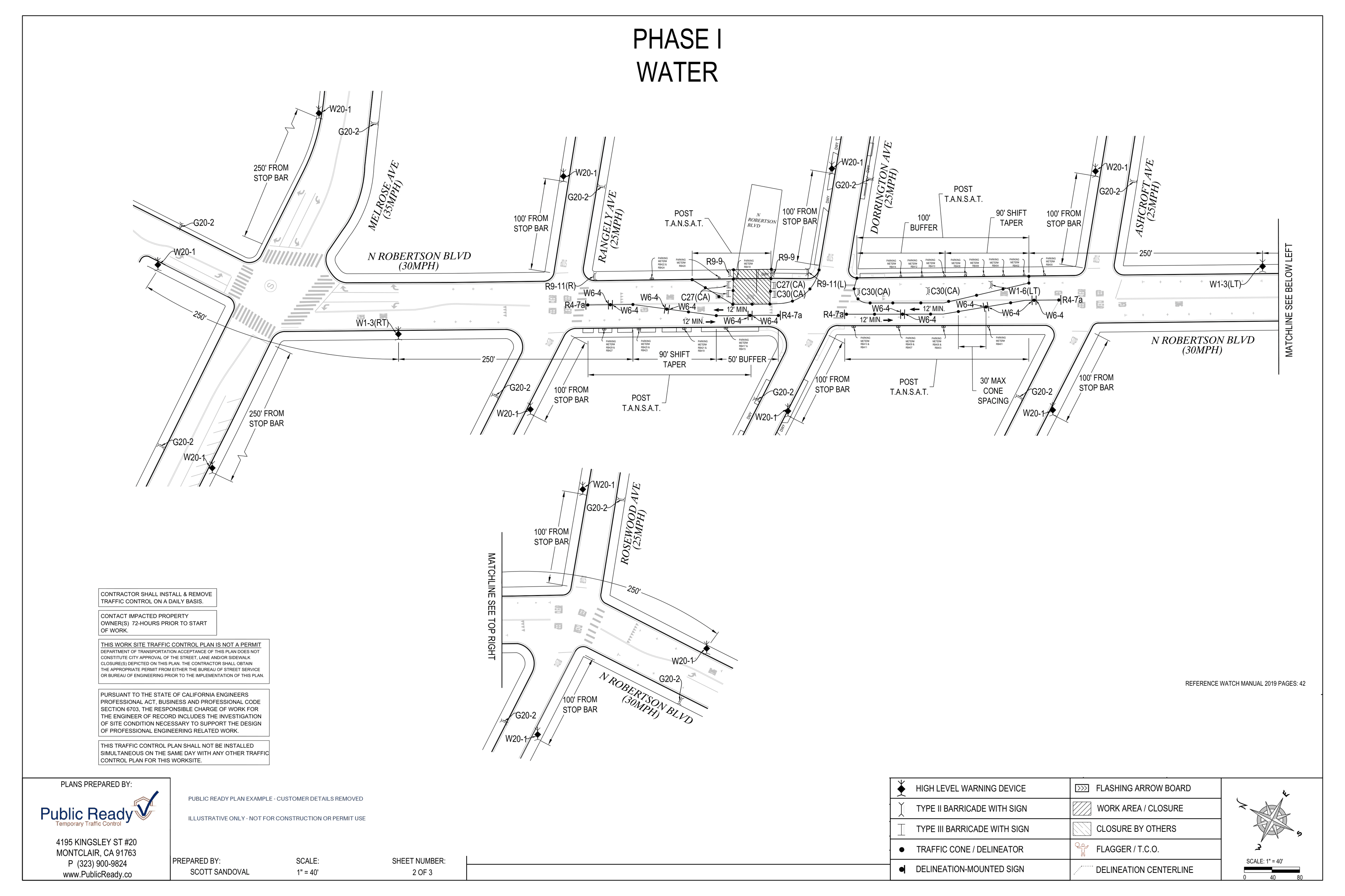
Read sheet 1 description
Sheet overview
The supplied drawing is original sheet 2 of 3, titled Phase I, Water. It shows North Robertson Boulevard between Melrose Avenue and Ashcroft Avenue, crossing Rangely Avenue and Dorrington Avenue. A lower continuation connects the matchline near Ashcroft Avenue to Rosewood Avenue.
Layout and relationships
A hatched utility work area lies on the upper curbside of North Robertson Boulevard between Rangely Avenue and Dorrington Avenue. Cones shift the through lanes around the work, with lanes labeled 12 feet minimum. W6-4 markings appear repeatedly along the separating cone lines; C27(CA), C30(CA), R4-7a, W1-6(LT), and W1-3 directional signs are also called out.
The approaches include 90-foot shift tapers, 100-foot and 50-foot buffers, and 30-foot maximum cone spacing. W20-1 and G20-2 sign pairs are placed on the main street and side streets. Sign distances are labeled 250 feet at the Melrose approaches and 100 feet from stop bars at the smaller side streets. The far-right matchline reads See Below Left; the lower continuation reads See Top Right.
R9-9 sidewalk-closed signs flank the work area; R9-11(R) and R9-11(L) pedestrian signs are shown at the adjacent corners. Parking meters on both sides are individually labeled, and several curb stretches carry the instruction Post T.A.N.S.A.T. The abbreviation is retained as printed, without an assumed expansion.
North Robertson Boulevard is labeled 30 mph; Melrose Avenue 35 mph; Rangely, Dorrington, Ashcroft, and Rosewood avenues 25 mph. The title block states 1 inch equals 40 feet, and the graphic scale and rotated north arrow are at lower right. The device legend identifies warning devices, barricades, cones, mounted signs, the arrow board, work and other-closure hatching, a flagger or traffic control officer, and the delineation centerline.
Notes on the historical example
These notes describe the redacted drawing. They apply to the original example and may not reflect current agency requirements. They are not instructions for a new project.
- Historical notes call for daily installation and removal of traffic control and contacting impacted property owners 72 hours before work.
- The sheet states that the work-site traffic control plan is not a permit and that transportation acceptance does not itself authorize the depicted street, lane, or sidewalk closure. The original note names the Bureau of Street Service or Bureau of Engineering for appropriate permitting before implementation.
- A historical engineering note references California Business and Professions Code section 6703 and describes investigation of site conditions as part of the engineer of record’s responsible charge. This description reports the old drawing text; it does not establish current legal requirements.
- The drawing says not to install this plan simultaneously with another traffic control plan for this worksite on the same day. It cites WATCH Manual 2019, page 42.
- Only one sheet of the original three-sheet set is supplied; customer details have been removed. The copy is illustrative only, not for construction or permit use.
LET’S GET YOUR PROJECT READY