

Los Angeles sidewalk closure plan
A Public Ready sidewalk closure example showing pedestrian access, signs, and the work-area footprint along Hollywood Boulevard in Los Angeles.
DRAFTED BY PUBLIC READY
What this example shows.
- Sidewalk work-area footprint
- Pedestrian access and accessible-route notes
- Advance warning and sidewalk signs
One supplied sheet from a two-sheet plan set; the original sheet numbering is retained.
Sidewalk closure and pedestrian access layout - original sheet 2 of 2
Open full-size image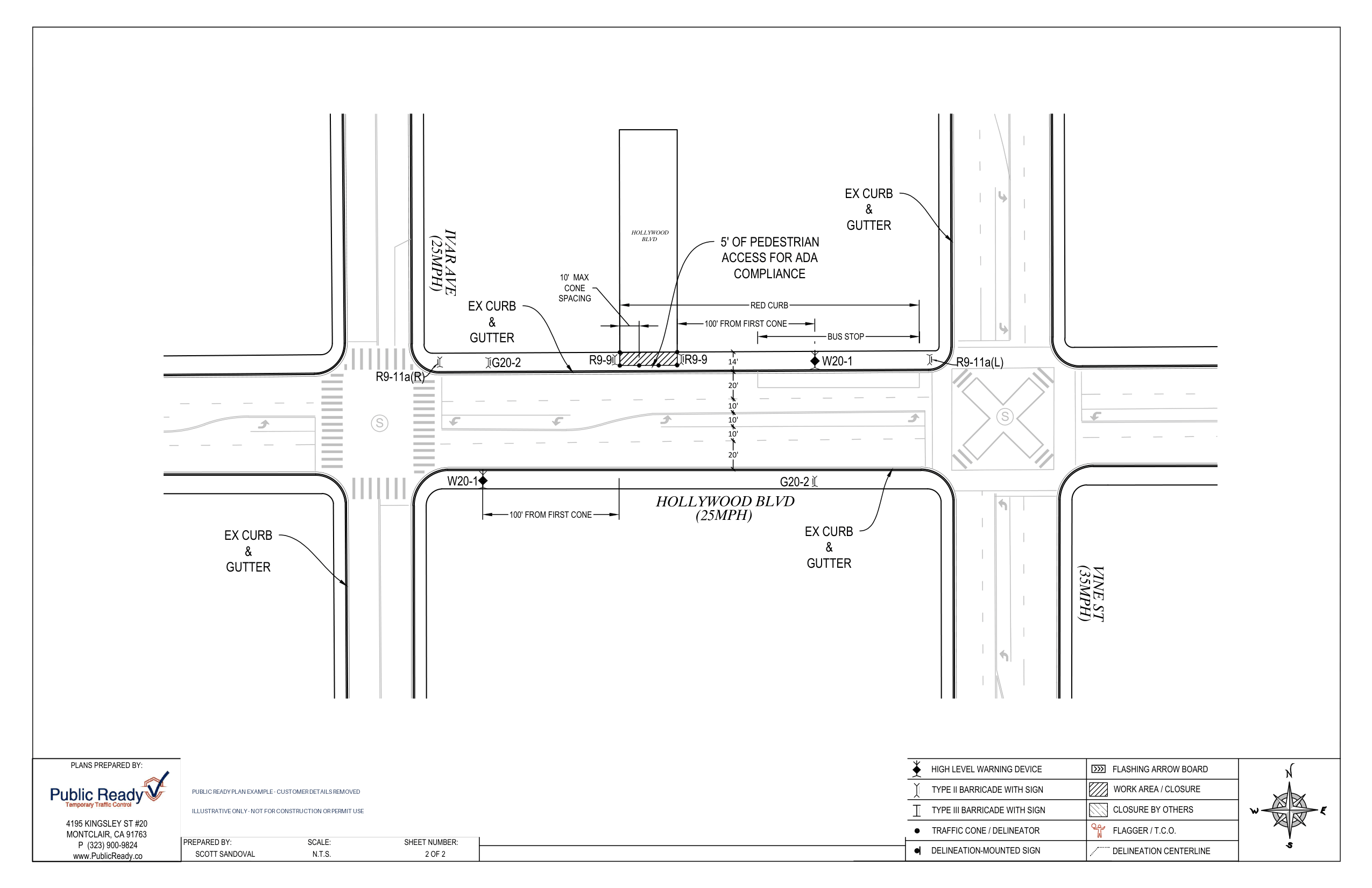
Read sheet 1 description
Sheet overview
The supplied drawing is original sheet 2 of 2, a not-to-scale sidewalk-closure plan on Hollywood Boulevard between Ivar Avenue and Vine Street in Los Angeles. Hollywood Boulevard runs across the page; Ivar Avenue is at the left and Vine Street at the right.
Layout and relationships
A small diagonally hatched work area interrupts the sidewalk on the upper side of Hollywood Boulevard, west of the marked bus stop. The drawing labels a five-foot pedestrian-access space beside the work for ADA compliance and 10-foot maximum cone spacing. R9-9 Sidewalk Closed signs mark the two edges of the affected sidewalk area.
R9-11a(R) is shown at the Ivar Avenue corner and R9-11a(L) at Vine Street, directing the pedestrian route at the crosswalk approaches. The roadway shows existing lane arrows and crosswalks, including the diagonal crosswalk markings at Vine Street. Existing curb and gutter, red curb, and the bus stop are labeled.
W20-1 road-work warning signs are shown on opposite approaches, with a 100-foot distance from the first cone. G20-2 end-road-work signs face departing traffic. The roadway cross-section labels 20-foot outer spaces and three 10-foot central spaces; a separate 14-foot callout appears at the upper curbside area. Hollywood Boulevard and Ivar Avenue are labeled 25 mph; Vine Street is labeled 35 mph.
The device legend distinguishes high-level warning devices, Type II and III barricades with signs, cones or delineators, delineation-mounted signs, a flashing arrow board, work-area hatching, closure-by-others hatching, a flagger or traffic control officer, and a delineation centerline. A north arrow points toward the top of the drawing.
Notes on the historical example
These notes describe the redacted drawing. They apply to the original example and may not reflect current agency requirements. They are not instructions for a new project.
- Only sheet 2 of the original two-sheet set is supplied. The title block states N.T.S., identifies Public Ready as the preparer, and preserves the original sheet number.
- The visible copy is marked illustrative only, not for construction or permit use; customer details have been removed.
LET’S GET YOUR PROJECT READY